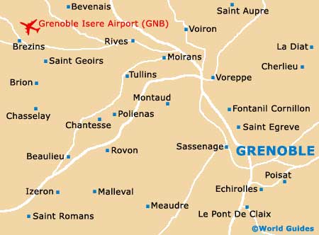
Grenoble Isere Airport (GNB)
City Orientation and Maps
(Grenoble, France)
Grenoble is a particularly beautiful city, located alongside both the Isère River and the Drac River. Grenoble is known for its spectacular mountainous scenery and contains a number of notable universities and colleges, with a large student base.
A thriving tourist hotspot, each year almost one million visitors fly into Grenoble Isere Airport (GNB), many of which head to the nearby ski resorts. Prominent locations close to Grenoble include Bron, Lyon, Venissieux and Villeurbanne to the north-west, Romans-sur-Isère to the west, and Enchirolles to the south.
Grenoble Isere Airport (GNB) Maps: Important City Districts
Both the Gare SCNF and the Gare Routière are sited along the Avenue Félix Viallet, just a short walk from many appealing sights and interesting neighbourhoods, to the west of the Isère River. A number of historic bridges connect the appealing St. Laurent quarter, which is known for its medieval architecture.
Grenoble's tourist information centre is situated close to the Place Grenette, on the Rue de la République, and boasts a range of useful leaflets and maps of this part of France. One of the best ways to start your sightseeing of the Grenoble area is to take a trip on the téléférique cable cars, which transport you high above the valley to Fort de la Bastille, where the view is quite breathtaking.
France Map

Grenoble Map